

 Band Difference
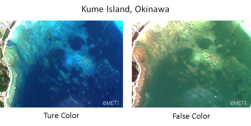
(Note) These images were processed for web display use.
Earth observation satellite has many observation bands. One big difference is the radio wave and the optical. Optical satellite has not only visible band but also non-visible bands, such as infrared band. This article introduce the example images which taken by these bands.
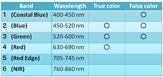
The first one is Kume Island, in Okinawa. It’s taken by the multi band optical satellite. Ture color image uses regular visible bands data, i.e., Red, Blue, Green. False color image uses Coastal blue instead of Red. False color image indicates bank under the water more clearly.
(Note) These images were processed for web display use.
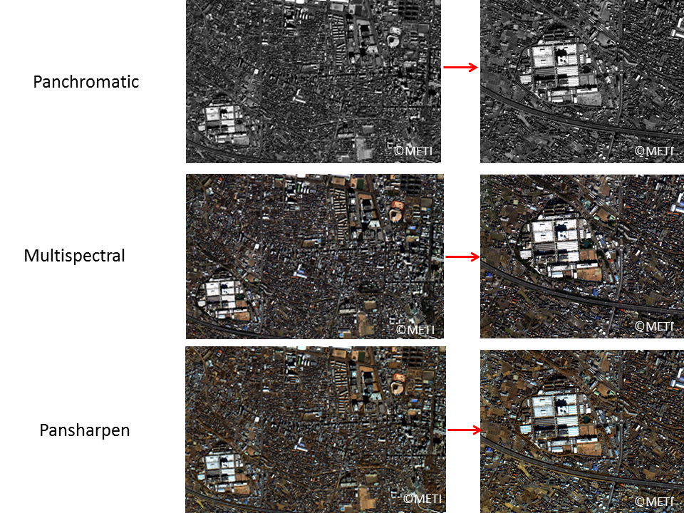
Multispectral band data easily makes the characteristic ground images. On the other hand, if we want check the details, Panchromatic band is used. Panchromatic has only one band and it includes the wave length of 450-860 nm. This covers almost Multispectral band. In case of ASNARO, the resolution is 0.5m for Panchromatic, and 2m for Multispectral. Above images are the examples of these modes. And the third one is Pansharpen. It uses basically Panchromatic and adds color of Multispectral. It combined the good points of both. Referring the colors we can distinguish the details of image by Panchromatic resolution.
These images were taken by ASNARO-1 on the following date and processed for web display use.
First one (Kume Island) : 2016 October 6
Second one (Fuchu) : 2015 May 7
(Note) The images in this article are based on the results of outsourcing projects of the Ministry of Economy, Trade and Industry.
ASNARO-1:http://www.jspacesystems.or.jp/en_project_asnaro/
Courtesy of METI : http://www.meti.go.jp/policy/mono_info_service/mono/space_industry/
Earth observation satellite has many observation bands. One big difference is the radio wave and the optical. Optical satellite has not only visible band but also non-visible bands, such as infrared band. This article introduce the example images which taken by these bands.
The first one is Kume Island, in Okinawa. It’s taken by the multi band optical satellite. Ture color image uses regular visible bands data, i.e., Red, Blue, Green. False color image uses Coastal blue instead of Red. False color image indicates bank under the water more clearly.
(Note) These images were processed for web display use.
Multispectral band data easily makes the characteristic ground images. On the other hand, if we want check the details, Panchromatic band is used. Panchromatic has only one band and it includes the wave length of 450-860 nm. This covers almost Multispectral band. In case of ASNARO, the resolution is 0.5m for Panchromatic, and 2m for Multispectral. Above images are the examples of these modes. And the third one is Pansharpen. It uses basically Panchromatic and adds color of Multispectral. It combined the good points of both. Referring the colors we can distinguish the details of image by Panchromatic resolution.
These images were taken by ASNARO-1 on the following date and processed for web display use.
First one (Kume Island) : 2016 October 6
Second one (Fuchu) : 2015 May 7
(Note) The images in this article are based on the results of outsourcing projects of the Ministry of Economy, Trade and Industry.
ASNARO-1:http://www.jspacesystems.or.jp/en_project_asnaro/
Courtesy of METI : http://www.meti.go.jp/policy/mono_info_service/mono/space_industry/