

 Disaster Monitor
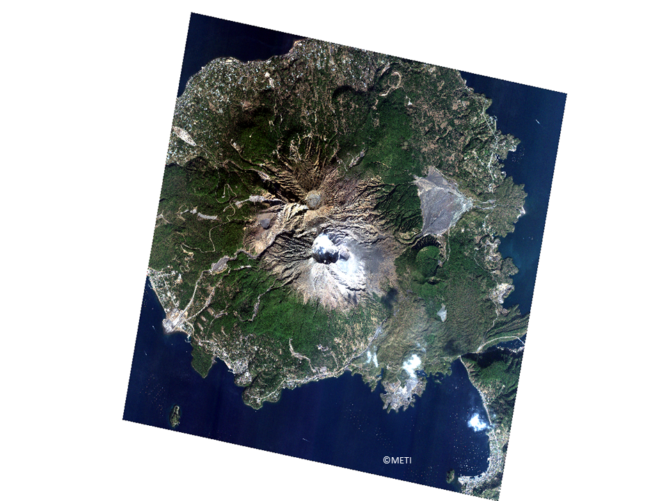
(Note) These images were processed for web display use.
Earth observation satellites could monitor the place where is some dangerous on ground or could not be taken image from an airplane. One typical example is a volcano. A volcano has dangerous aspect, i.e., we could not know when it will start explosion. This image is Mt. Sakurajima in Kagoshima Prefecture in Japan. It is one of the active volcanos and it makes many effects to the nearby residents.
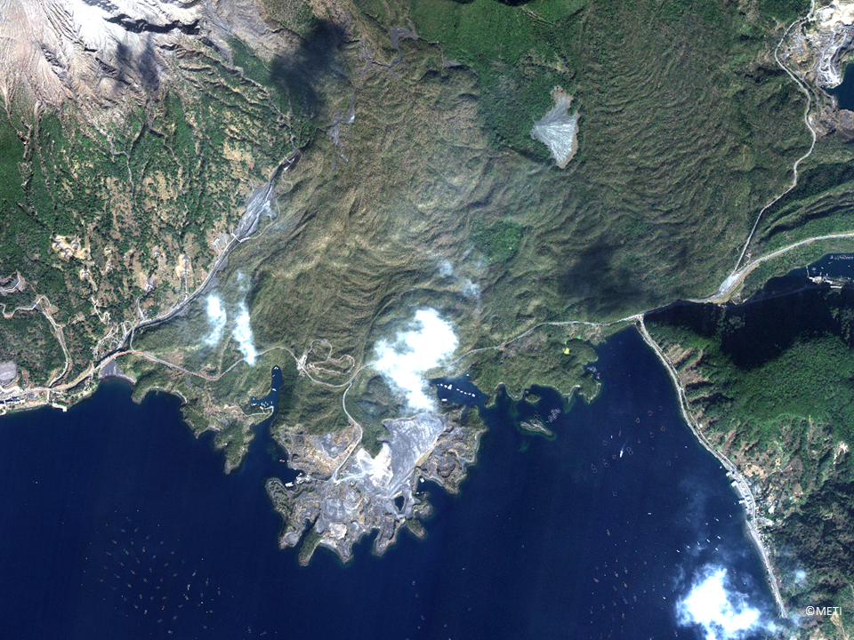
Mt. Sakurajima (literally it is Cherry Blossoms Island) is 1,117m high and it was originally a real island. But in 1914, it made big explosions and it combined with Osumi Peninsula. Now it has two major craters. Its activity is some times high and regularly surveillances are made. Following images shows these two craters and the connecting point to Osumi Peninsula. Typical lava is observed from the center to the seashore. Also we can see many fishing rafts at bay. Connecting made nice calm points for fishing in this area. Volcano makes many disasters but also it leaves many benefits.

(Note) These images were processed for web display use.
(Note) These images were processed for web display use.
Next is a flood disaster.
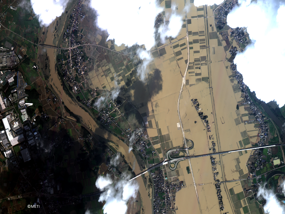
In September 2015, the wide area of eastern Japan was attacked by heavy rains.
The following image is Joso City where Kinugawa River made flood. The river colored to beige with sands and it overflowed to rice fields. These were unexperienced damage to the people. Joso City has Kinugawa River in central with very flat area. This means some potential of disaster.
(Note) These images were processed for web display use.
On the other hand, in Miyagi Prefecture experienced same kind of damage. The following image is at Taiwa Town. The beige water run down in the river and overflowed to rice fields. We can distinguish many blue sheets on roof which is used to the instant repair of the damaged roof.
(Note) These images were processed for web display use.
These images were taken in the following days by ASNARO-1 and processed for web display use.
Image 1 (Sakurajima Island) 2016/02/07
Image 2 (Joso City) 2015/09/12
Image 3 (Taiwa Town) 2015/09/17
(Note) The images in this article are based on the results of outsourcing projects of the Ministry of Economy, Trade and Industry.
ASNARO-1:http://www.jspacesystems.or.jp/en_project_asnaro/
Courtesy of METI : http://www.meti.go.jp/policy/mono_info_service/mono/space_industry/
Earth observation satellites could monitor the place where is some dangerous on ground or could not be taken image from an airplane. One typical example is a volcano. A volcano has dangerous aspect, i.e., we could not know when it will start explosion. This image is Mt. Sakurajima in Kagoshima Prefecture in Japan. It is one of the active volcanos and it makes many effects to the nearby residents.
Mt. Sakurajima (literally it is Cherry Blossoms Island) is 1,117m high and it was originally a real island. But in 1914, it made big explosions and it combined with Osumi Peninsula. Now it has two major craters. Its activity is some times high and regularly surveillances are made. Following images shows these two craters and the connecting point to Osumi Peninsula. Typical lava is observed from the center to the seashore. Also we can see many fishing rafts at bay. Connecting made nice calm points for fishing in this area. Volcano makes many disasters but also it leaves many benefits.
(Note) These images were processed for web display use.
(Note) These images were processed for web display use.
Next is a flood disaster.
In September 2015, the wide area of eastern Japan was attacked by heavy rains.
The following image is Joso City where Kinugawa River made flood. The river colored to beige with sands and it overflowed to rice fields. These were unexperienced damage to the people. Joso City has Kinugawa River in central with very flat area. This means some potential of disaster.
(Note) These images were processed for web display use.
On the other hand, in Miyagi Prefecture experienced same kind of damage. The following image is at Taiwa Town. The beige water run down in the river and overflowed to rice fields. We can distinguish many blue sheets on roof which is used to the instant repair of the damaged roof.
(Note) These images were processed for web display use.
These images were taken in the following days by ASNARO-1 and processed for web display use.
Image 1 (Sakurajima Island) 2016/02/07
Image 2 (Joso City) 2015/09/12
Image 3 (Taiwa Town) 2015/09/17
(Note) The images in this article are based on the results of outsourcing projects of the Ministry of Economy, Trade and Industry.
ASNARO-1:http://www.jspacesystems.or.jp/en_project_asnaro/
Courtesy of METI : http://www.meti.go.jp/policy/mono_info_service/mono/space_industry/